
Chongfan Technology
News
07
2026
-
09
The team at the Anhui Institute of Optics and Fine Mechanics has achieved a series of breakthroughs in the field of intelligent perception of optical remote-sensing targets.
Author:
Recently, the team at the Optoelectronics Center of the Anhui Institute of Optics and Fine Mechanics has achieved a series of breakthroughs in the field of intelligent perception for optical remote-sensing targets. They have successively proposed GeoAdapt, a lightweight keypoint‑localization framework, and Freq‑LoRA, a frequency‑domain low‑rank adaptive segmentation method, which respectively enable fine‑grained localization of aerial target keypoints and robust segmentation under adverse weather conditions. The related research findings have been published in the internationally renowned remote-sensing journal Remote Sensing, under the titles “GeoAdapt: Fine‑Grained Keypoint Localization via Deformable Feature Refinement for Ground‑Based Optical Remote Sensing” and “Freq‑LoRA: Frequency‑Domain Low‑Rank Adaptation for Weather‑Robust Aircraft Segmentation in EO Remote Sensing.”
Ground-based optical remote sensing is a crucial means for long-range surveillance of airborne targets. However, at kilometer-scale ranges, target imaging is often subject to adverse conditions such as illumination variations, motion blur, atmospheric attenuation, and even rain or fog, leading to pervasive issues like small image sizes, weak textural details, and low signal-to-noise ratios. These challenges pose significant difficulties for keypoint localization, pose estimation, and reliable segmentation. Meanwhile, the requirements for edge deployment and real-time processing further demand greater algorithmic lightweighting.
To address the challenges of keypoint localization, pose estimation, and object segmentation for aerial targets in complex environments, the research team proposed two innovative approaches: the lightweight keypoint detection framework GeoAdapt and the frequency-domain low-rank adaptive method Freq‑LoRA. Specifically, GeoAdapt incorporates deformable convolution v2 (DCNv2) at three scales within the feature pyramid network and employs a combined loss function consisting of Wing Loss and Bone Loss, thereby enhancing the model’s ability to adaptively capture local structural details and geometric relationships. Zero-shot validation was conducted using a self‑constructed dataset of 10,000 frames that covers diverse lighting conditions and imaging degradations, as well as publicly available datasets from ScanEagle and Matrice200. Experimental results demonstrate that GeoAdapt contains only 5.95 million parameters—47.9% fewer than YOLOv8s‑pose—while achieving a PCK@0.05D of 89.3% and a rotation error of 11.6°. Compared with YOLOv8s‑pose, GeoAdapt improves PCK by 11.7 percentage points, showcasing strong cross‑domain generalization capabilities and advantages in lightweight deployment.
To address the degradation of aerial target segmentation performance under adverse weather conditions, Freq‑LoRA performs a DCT‑II frequency‑domain decomposition on the frozen SAM image encoder’s features, partitioning them into four learnable Gaussian frequency bands. It then employs an image‑driven spectral gating module—containing only 140 parameters—to adaptively modulate each band based on the input image’s own frequency‑domain statistical characteristics, without requiring additional weather class labels or environmental metadata. This approach requires just 559K trainable parameters, approximately 1/168th of the full fine‑tuning parameter count; on a simulated dataset spanning five weather conditions, it achieves an average Intersection over Union (IoU) of 0.904, reaching 96.1% of the performance of full fine‑tuning, and demonstrates robustness across real drone imagery as well as six unseen image degradation scenarios.
These two approaches enhance the intelligent perception capabilities of ground-based optical remote sensing for airborne targets by addressing both point-level localization and region-level segmentation, thereby offering new technical avenues for the automatic identification, pose estimation, and all-weather surveillance of flying objects under complex illumination and adverse weather conditions.
Senior Engineer Xia Yingwei of the Anhui Institute of Optics and Fine Mechanics served as the first author of both papers, with Master’s student Yu Tian as the second author, and Associate Researcher Zhang Wen as the corresponding author. This research was supported by the Central Government‑Guided Local Science and Technology Development Special Fund Project (202407a12020013).
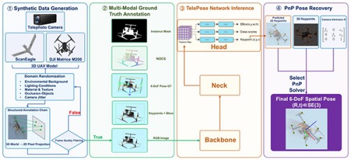
GeoAdapt Framework Diagram
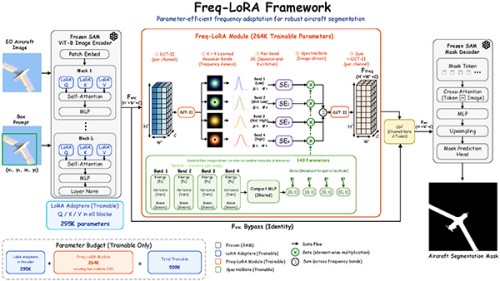
Freq-LoRA framework diagram
Source: Anhui Institute of Optics and Fine Mechanics
LATEST NEWS
Thank you for visiting the official website of Chongfan Technology. If you have cooperation intentions or suggestions, please contact us through the following methods, and we will reply as soon as possible, thank you!
Address: Room 403, Building 6, Phase III of R&D, No. 36 Xiyong Avenue, High tech Zone, Chongqing, China.
Telephone: +86-13658337211
E-mail: Sales@cfkeji.net
Website: www.cfkeji.net
Mobile Version