Chongfan Technology
News
29
2026
-
04
Two payloads from the Anhui Institute of Optics and Fine Mechanics have been successfully launched aboard a high-precision greenhouse gas comprehensive observation satellite.
Author:
On April 17, the High-Precision Greenhouse Gas Comprehensive Detection Satellite (DQ-2) was successfully launched from the Jiuquan Satellite Launch Center in Gansu Province. DQ-2 is equipped with a combined active–passive remote-sensing capability that enables high-spectral-resolution and high-temporal-resolution measurements of atmospheric environmental parameters, including greenhouse gases, pollutant gases, and aerosols.
The satellite carries a total of five payloads, two of which—the Extreme Ultraviolet High-Resolution Spectrometer for Atmospheric Composition (EMI-NL) and the Cloud and Aerosol Polarimetric Camera (CAPC)—were independently developed by the Anhui Institute of Optics and Fine Mechanics, Chinese Academy of Sciences.
EMI-NL: Achieving the World’s First Simultaneous Nadir and Limb Imaging Observations
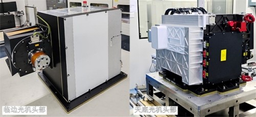
Ultraviolet Hyperspectral Atmospheric Composition Sounder (EMI-NL)
EMI-NL is the third-generation hyperspectral atmospheric trace-gas monitoring payload developed by the Institute of Optics and Electronics, Chinese Academy of Sciences. It is designed to quantitatively monitor the three-dimensional distribution of global and regional trace pollutants—including nitrogen dioxide, sulfur dioxide, ozone, and formaldehyde—thereby enabling analysis of the impacts of anthropogenic activities and natural emission processes on atmospheric composition and global climate change. This payload features an innovative dual-optical-head configuration that includes both nadir and limb viewing capabilities: the nadir head enables horizontal profiling of atmospheric constituents, while the limb head captures the vertical structure of the atmosphere, thus providing comprehensive, three-dimensional atmospheric sensing. Notably, it achieves, for the first time internationally, simultaneous observations of these two modes using imaging technology.
Notably, the nadir-viewing instrument’s optical head employs a wide-field ultraviolet hyperspectral imaging and detection technology, enabling the acquisition of atmospheric reflected and scattered UV–visible radiation at sub-nanometer resolution and precise extraction of weak absorption signals from trace atmospheric gases. Through optimization of key design elements—including a wide-field telephoto imaging system, an aberration-corrected hyperspectral imaging system, and low-noise photodetection—the team has overcome critical technical bottlenecks related to ultra-wide swath, high spatial resolution, and hyperspectral detection. As a result, the instrument’s spatial resolution has been significantly improved compared with the previous-generation payload, ultimately achieving 7-kilometer spatial resolution and reaching an internationally advanced level.
The limb-scan instrument aboard the satellite performs lateral scanning of the Earth’s atmospheric limb, measuring the solar scattering and emission spectra at tangent lines at various altitudes to enable precise retrieval of vertical profiles of atmospheric constituents. The team has innovatively adopted a limb-imaging observation mode, integrating high-precision scanning with ultraviolet hyperspectral imaging technology, which allows regional scanning from a nadir point at a distance of 3,000 kilometers, with a spatial resolution better than 2 kilometers and a swath width of 320 kilometers. This new observational mode addresses the limitation of insufficient vertical resolution in nadir-only observations, providing global three-dimensional observational data for studies on stratosphere–troposphere exchange, ozone depletion, source tracing of tropospheric pollution, and climate radiative forcing, among others.
EMI-NL’s kilometer-scale spatial resolution and simultaneous nadir–limb dual-mode observations can effectively support the identification of pollution source locations, the quantification of point-source and area-source emission fluxes, and the assessment of interregional interactions.
CAPC: Conducting Global High-Resolution Cloud and Aerosol Detection
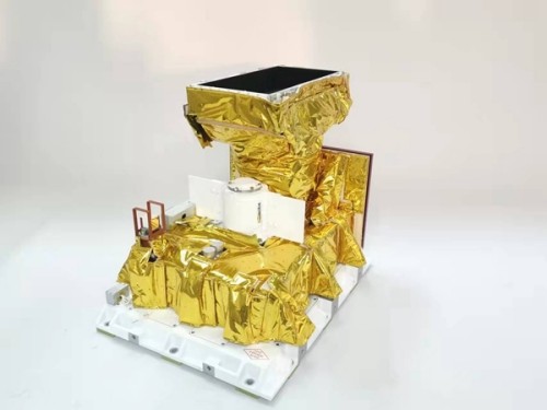
Cloud and Aerosol Particle Counter (CAPC)
CAPC is used to acquire multi-angle, multispectral polarimetric radiance data. By integrating polarization-based atmospheric property retrieval models, it generates global products on atmospheric aerosol and cloud characteristics, providing observational data support for monitoring particulate matter pollution in the atmospheric environment and supplying atmospheric correction data for other payloads aboard satellites.
This payload employs wide-field radiative polarization measurement technology. Compared with previous models, the multi-angle polarimetric imager features enhanced spatial resolution and optimized spectral-band and field-of-view configurations tailored to the target observation requirements, enabling time-resolved acquisition of high-precision, multi-angle, multi-spectral, polarimetric radiance information on clouds and atmospheric aerosols. Furthermore, a multi-parameter optimal inversion model based on polarization data can provide spatiotemporal distributions of optical microphysical properties of global clouds and atmospheric aerosols, thereby furnishing more refined environmental parameters for high-precision greenhouse-gas retrieval, reducing the interference of clouds and aerosols on observational data, and enhancing the effectiveness and accuracy of satellite remote-sensing monitoring of greenhouse gases.
Following its orbital insertion, the DQ-2 satellite will form a morning–afternoon networked cooperative observation configuration with the DQ-1 satellite, enabling high-precision, comprehensive monitoring of global atmospheric composition. Its data will support operational applications in such fields as ecological environment, natural resources, agriculture and rural development, forestry and grassland management, and meteorology, thereby providing robust support for China’s efforts to build an eco-environmental civilization.
Source: Anhui Institute of Optics and Fine Mechanics
LATEST NEWS
Thank you for visiting the official website of Chongfan Technology. If you have cooperation intentions or suggestions, please contact us through the following methods, and we will reply as soon as possible, thank you!
Address: Room 403, Building 6, Phase III of R&D, No. 36 Xiyong Avenue, High tech Zone, Chongqing, China.
Telephone: +86-13658337211
E-mail: Sales@cfkeji.net
Website: www.cfkeji.net
Mobile Version